year :: 2014
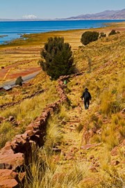
Qhapaq Ñan
This site is an extensive Inca communication, trade and defence network of roads covering 30,000 km. Constructed by the Incas over several centuries and partly based on pre-Inca infrastructure, this extraordinary network through one of the world’s most extreme geographical terrains linked the snow-capped peaks of the Andes – at an altitude of more than 6,000 m – to the coast, running through hot rainforests, fertile valleys and absolute deserts. It reached its maximum expansion in the 15th century, w... Read More
Silk Roads
This property is a 5,000 km section of the extensive Silk Roads network, stretching from Chang’an/Luoyang, the central capital of China in the Han and Tang dynasties, to the Zhetysu region of Central Asia. It took shape between the 2nd century BC and 1st century AD and remained in use until the 16th century, linking multiple civilizations and facilitating far-reaching exchanges of activities in trade, religious beliefs, scientific knowledge, technological innovation, cultural practices and the arts. The thi... Read More

Okavango Delta
This delta in north-west Botswana comprises permanent marshlands and seasonally flooded plains. It is one of the very few major interior delta systems that do not flow into a sea or ocean, with a wetland system that is almost intact. One of the unique characteristics of the site is that the annual flooding from the River Okavango occurs during the dry season, with the result that the native plants and animals have synchronized their biological cycles with these seasonal rains and floods. It is an exceptiona... Read More
Grand Canal
The Grand Canal is a vast waterway system in the north-eastern and central-eastern plains of China, running from Beijing in the north to Zhejiang province in the south. Constructed in sections from the 5th century BC onwards, it was conceived as a unified means of communication for the Empire for the first time in the 7th century AD (Sui dynasty). This led to a series of gigantic construction sites, creating the world’s largest and most extensive civil engineering project prior to the Industrial Revolution.... Read More
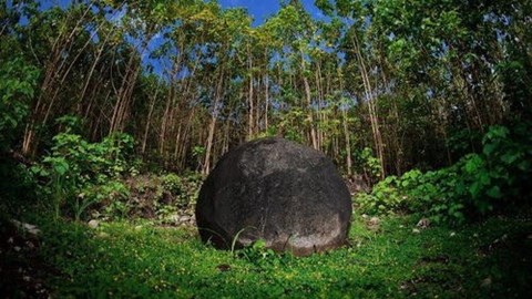
Stone Spheres of the Diquís
The property includes four archaeological sites located in the Diquís Delta in southern Costa Rica, which are considered unique examples of the complex social, economic and political systems of the period AD 500–1500. They contain artificial mounds, paved areas, burial sites and, most significantly, a collection of stone spheres, between 0.7 m and 2.57 m in diameter, whose meaning, use and production remain largely a mystery. The spheres are distinctive for their perfection, numb... Read More
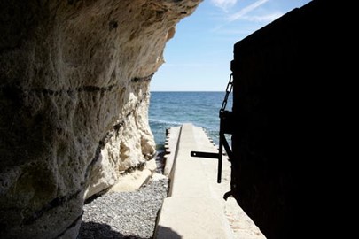
Stevns Klint
This geological site comprises a 15 km-long fossil-rich coastal cliff, offering exceptional evidence of the impact of the Chicxulub meteorite that crashed into the planet at the end of the Cretaceous, about 65 million years ago. Researchers think that this caused the most remarkable mass extinction ever, responsible for the disappearance of over 50 per cent of all life on Earth. The site harbours a record of the cloud of ash formed by the impact of the meteorite – the exact site being at the bottom of the o... Read More
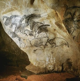
Decorated Cave of Pont d’Arc
Located in a limestone plateau of the Ardèche River in southern France, the property contains the earliest-known and best-preserved figurative drawings in the world, dating back as early as the Aurignacian period (30,000–32,000 BP), making it an exceptional testimony of prehistoric art. The cave was closed off by a rock fall approximately 20,000 years BP and remained sealed until its discovery in 1994, which helped to keep it in pristine condition. Over 1,000 images have so far been inventoried on its walls... Read More
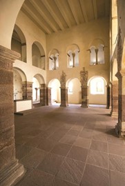
Corvey Abbey
The site is located along the Weser River on the outskirts of Höxter where the Carolingian Westwork and Civitas Corvey were erected between AD 822 and 885 in a largely preserved rural setting. The Westwork is the only standing structure that dates back to the Carolingian era, while the original imperial abbey complex is preserved as archaeological remains that are only partially excavated. The Westwork of Corvey uniquely illustrates one of the most important Carolingian architectural expressions. It is a ge... Read More

Rani ki Vav
Rani-ki-Vav, on the banks of the Saraswati River, was initially built as a memorial to a king in the 11th century AD. Stepwells are a distinctive form of subterranean water resource and storage systems on the Indian subcontinent, and have been constructed since the 3rd millennium BC. They evolved over time from what was basically a pit in sandy soil towards elaborate multi-storey works of art and architecture. Rani-ki-Vav was built at the height of craftsmens’ ability in stepwell construction and the ... Read More
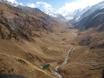
Great Himalayan
This National Park in the western part of the Himalayan Mountains in the northern Indian state of Himachal Pradesh is characterized by high alpine peaks, alpine meadows and riverine forests. The 90,540 ha property includes the upper mountain glacial and snow meltwater sources of several rivers, and the catchments of water supplies that are vital to millions of downstream users. The GHNPCA protects the monsoon-affected forests and alpine meadows of the Himalayan front ranges. It is part of the Himalaya ... Read More
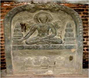
Shahr i Sokhta
Shahr-i Sokhta, meaning ‘Burnt City’, is located at the junction of Bronze Age trade routes crossing the Iranian plateau. The remains of the mudbrick city represent the emergence of the first complex societies in eastern Iran. Founded around 3200 BC, it was populated during four main periods up to 1800 BC, during which time there developed several distinct areas within the city: those where monuments were built, and separate quarters for housing, burial and manufacture. Diversions in water courses and clima... Read More
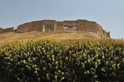
Erbil Citadel
Erbil Citadel is a fortified settlement on top of an imposing ovoid-shaped tell (a hill created by many generations of people living and rebuilding on the same spot) in the Kurdistan region, Erbil Governorate. A continuous wall of tall 19th-century façades still conveys the visual impression of an impregnable fortress, dominating the city of Erbil. The citadel features a peculiar fan-like pattern dating back to Erbil’s late Ottoman phase. Written and iconographic historical records document the antiquity of... Read More
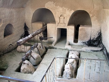
Caves of Maresha and Bet Guvrin
The archaeological site contains some 3,500 underground chambers distributed among distinct complexes carved in the thick and homogenous soft chalk of Lower Judea under the former towns of Maresha and Bet Guvrin. Situated on the crossroads of trade routes to Mesopotamia and Egypt, the site bears witness to the region’s tapestry of cultures and their evolution over more than 2,000 years from the 8th century BCE—when Maresha, the older of the two towns was built—to the time of the Crusaders. These ... Read More
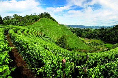
Vineyard Landscape of Piedmont
This landscape covers five distinct wine-growing areas with outstanding landscapes and the Castle of Cavour, an emblematic name both in the development of vineyards and in Italian history. It is located in the southern part of Piedmont, between the Po River and the Ligurian Apennines, and encompasses the whole range of technical and economic processes relating to the winegrowing and winemaking that has characterized the region for centuries. Vine pollen has been found in the area dating from the 5th century... Read More
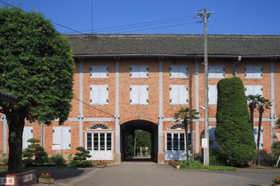
Tomioka Silk Mill
This property is a historic sericulture and silk mill complex established in the late 19th and early 20th century in the Gunma prefecture, north-west of Tokyo. It consists of four sites that correspond to the different stages in the production of raw silk: a large raw silk reeling plant whose machinery and industrial expertise were imported from France; an experimental farm for production of cocoons; a school for the dissemination of sericulture knowledge; and a cold-storage facility for silkworm eggs. The ... Read More
Pyu Ancient Cities
Pyu Ancient Cities includes the remains of three brick, walled and moated cities of Halin, Beikthano and Sri Ksetra located in vast irrigated landscapes in the dry zone of the Ayeyarwady (Irrawaddy) River basin. They reflect the Pyu Kingdoms that flourished for over 1,000 years between 200 BC and AD 900. The three cities are partly excavated archaeological sites. Remains include excavated palace citadels, burial grounds and manufacture sites, as well as monumental brick Buddhist stupas, partly standing wall... Read More
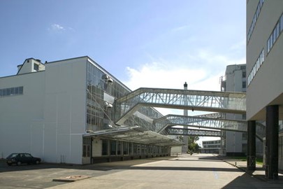
Van Nellefabriek
Van Nellefabriek was designed and built in the 1920s on the banks of a canal in the Spaanse Polder industrial zone north-west of Rotterdam. The site is one of the icons of 20th-century industrial architecture, comprising a complex of factories, with façades consisting essentially of steel and glass, making large-scale use of the curtain wall principle. It was conceived as an ‘ideal factory’, open to the outside world, whose interior working spaces evolved according to need, and in which d... Read More
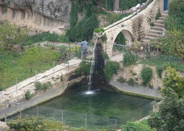
Battir
This site is located a few kilometres south-west of Jerusalem, in the Central Highlands between Nablus and Hebron. The Battir hill landscape comprises a series of farmed valleys, known as widian, with characteristic stone terraces, some of which are irrigated for market garden production, while others are dry and planted with grapevines and olive trees. The development of terrace farming in such a mountainous region is supported by a network of irrigation channels fed by underground sources. A traditional s... Read More
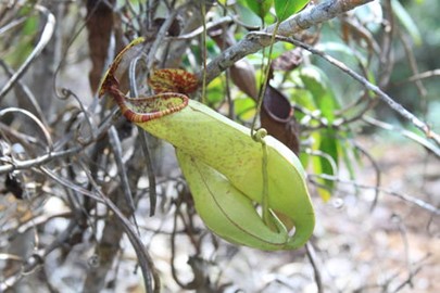
Mount Hamiguitan
Forming a mountain ridge running north-south along the Pujada Peninsula in the south-eastern part of the Eastern Mindanao Biodiversity Corridor, the Mount Hamiguitan Range Wildlife Sanctuary has an elevation range of 75–1,637 m above sea level and provides critical habitat for a range of plant and animal species. The property showcases terrestrial and aquatic habitats at different elevations, and includes threatened and endemic flora and fauna species, eight of which are found only at Mount Hamig... Read More
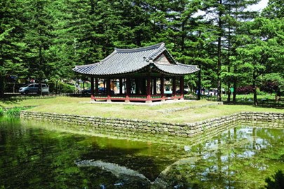
Namhansanseong
Namhansanseong was designed as an emergency capital for the Joseon dynasty (1392–1910), in a mountainous site 25 km south-east of Seoul. Built and defended by Buddhist monk-soldiers, it could accommodate 4,000 people and fulfilled important administrative and military functions. Its earliest remains date from the 7th century, but it was rebuilt several times, notably in the early 17th century in anticipation of an attack from the Sino-Manchu Qing dynasty. The city embodies a synthesis of the defensive milit... Read More
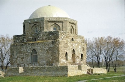
Bolgar
This property lies on the shores of the Volga River, south of its confluence with the River Kama, and south of the capital of Tatarstan, Kazan. It contains evidence of the medieval city of Bolgar, an early settlement of the civilization of Volga-Bolgars, which existed between the 7th and 15th centuries AD, and was the first capital of the Golden Horde in the 13th century. Bolgar represents the historical cultural exchanges and transformations of Eurasia over several centuries that played a pivotal role in t... Read More
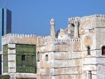
Jeddah
Historic Jeddah is situated on the eastern shore of the Red Sea. From the 7th century AD it was established as a major port for Indian Ocean trade routes, channelling goods to Mecca. It was also the gateway for Muslim pilgrims to Mecca who arrived by sea. These twin roles saw the city develop into a thriving multicultural centre, characterized by a distinctive architectural tradition, including tower houses built in the late 19th century by the city’s mercantile elites, and combining Red Sea coastal coral b... Read More
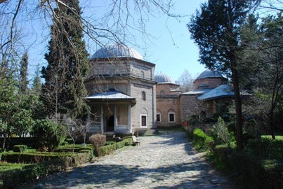
Bursa and Cumalikizik
This property is a serial nomination of eight component sites in the City of Bursa and the nearby village of Cumalıkızık, in the southern Marmara region. The site illustrates the creation of an urban and rural system establishing the Ottoman Empire in the early 14th century. The property embodies the key functions of the social and economic organization of the new capital which evolved around a civic centre. These include commercial districts of khans, kulliyes (religious institutions) integrating mosques, ... Read More
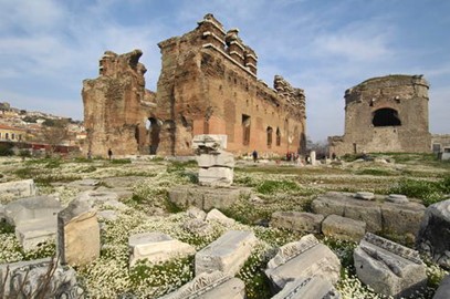
Pergamon
This site rises high above the Bakirçay Plain in Turkey’s Aegean region. The acropolis of Pergamon was the capital of the Hellenistic Attalid dynasty, a major centre of learning in the ancient world. Monumental temples, theatres, stoa or porticoes, gymnasium, altar and library were set into the sloping terrain surrounded by an extensive city wall. The rock-cut Kybele Sanctuary lies to the north-west on another hill visually linked to the acropolis. Later the city became capital of the Roman province of Asia... Read More
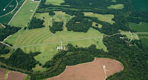
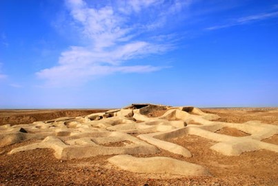
Poverty Point
Monumental Earthworks of Poverty Point owes its name to a 19th-century plantation close to the site, which is in the Lower Mississippi Valley on a slightly elevated and narrow landform. The complex comprises five mounds, six concentric semi-elliptical ridges separated by shallow depressions and a central plaza. It was created and used for residential and ceremonial purposes by a society of hunter fisher-gatherers between 3700 and 3100 BP. It is a remarkable achievement in earthen construction in North Ameri... Read More