category :: cultural
Muskauer Park
A landscaped park of 559.9 ha astride the Neisse River and the border between Poland and Germany, it was created by Prince Hermann von Puckler-Muskau from 1815 to 1844. Blending seamlessly with the surrounding farmed landscape, the park pioneered new approaches to landscape design and influenced the development of landscape architecture in Europe and America. Designed as a ‘painting with plants’, it did not seek to evoke classical landscapes, paradise, or some lost perfection, instead using loca... Read More
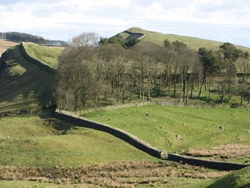
Frontiers of the Roman Empire
The ‘Roman Limes’ represents the border line of the Roman Empire at its greatest extent in the 2nd century AD. It stretched over 5,000 km from the Atlantic coast of northern Britain, through Europe to the Black Sea, and from there to the Red Sea and across North Africa to the Atlantic coast. The remains of the Limes today consist of vestiges of built walls, ditches, forts, fortresses, watchtowers and civilian settlements. Certain elements of the line have been excavated, some reconstructed and a few destroy... Read More
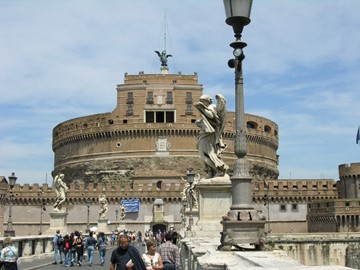
Rome
Founded, according to legend, by Romulus and Remus in 753 BC, Rome was first the centre of the Roman Republic, then of the Roman Empire, and it became the capital of the Christian world in the 4th century. The World Heritage site, extended in 1990 to the walls of Urban VIII, includes some of the major monuments of antiquity such as the Forums, the Mausoleum of Augustus, the Mausoleum of Hadrian, the Pantheon, Trajan’s Column and the Column of Marcus Aurelius, as well as the religious and public buildings of... Read More
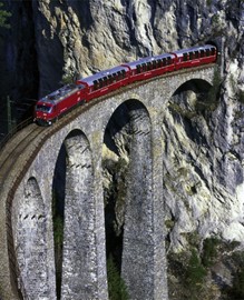
Rhaetian Railway
Rhaetian Railway in the Albula / Bernina Landscapes, brings together two historic railway lines that cross the Swiss Alps through two passes. Opened in 1904, the Albula line in the north western part of the property is 67 km long. It features an impressive set of structures including 42 tunnels and covered galleries and 144 viaducts and bridges. The 61 km Bernina pass line features 13 tunnels and galleries and 52 viaducts and bridges. The property is exemplary of the use of the railway to overcome the isola... Read More
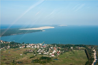
Curonian Spit
Human habitation of this elongated sand dune peninsula, 98 km long and 0.4-4 km wide, dates back to prehistoric times. Throughout this period it has been threatened by the natural forces of wind and waves. Its survival to the present day has been made possible only as a result of ceaseless human efforts to combat the erosion of the Spit, dramatically illustrated by continuing stabilisation and reforestation projects.
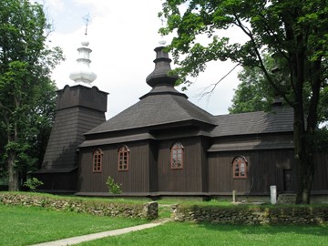
Wooden Tserkvas
Situated in the eastern fringe of Central Europe, the transnational property numbers a selection of sixteen tserkvas (churches). They were built of horizontal wooden logs between the 16th and 19th centuries by communities of Orthodox and Greek Catholic faiths. The tserkvas bear testimony to a distinct building tradition rooted in Orthodox ecclesiastic design interwoven with elements of local tradition, and symbolic references to their communities’ co... Read More
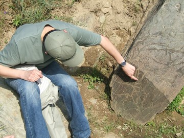
Côa Valley and Siega Verde
The two Prehistoric Rock Art Sites in the Côa Valley (Portugal) and Siega Verde (Spain) are located on the banks of the rivers Agueda and Côa, tributaries of the river Douro, documenting continuous human occupation from the end of the Paleolithic Age. Hundreds of panels with thousands of animal figures (5,000 in Foz Côa and around 440 in Siega Verde) were carved over several millennia, representing the most remarkable open-air ensemble of Paleolithic art on the Iberian Peninsula. Côa Valley and... Read More
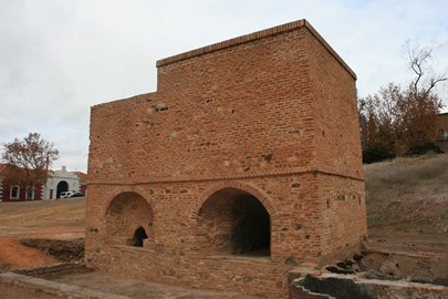
Heritage of Mercury
The property includes the mining sites of Almadén (Spain), where mercury (quicksilver) has been extracted since antiquity, and Idrija (Slovenia), where mercury was first found in AD1490. The Spanish property includes buildings relating to its mining history, including Retamar Castle, religious buildings and traditional dwellings. The site in Idrija notably features mercury stores and infrastructure, as well as miners’ living quarters, and a miners’ theatre. The sites bear testimony to the... Read More
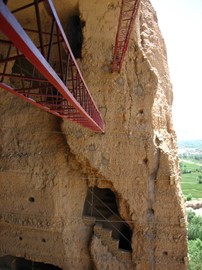
Bamiyan Valley
The cultural landscape and archaeological remains of the Bamiyan Valley represent the artistic and religious developments which from the 1st to the 13th centuries characterized ancient Bakhtria, integrating various cultural influences into the Gandhara school of Buddhist art. The area contains numerous Buddhist monastic ensembles and sanctuaries, as well as fortified edifices from the Islamic period. The site is also testimony to the tragic destruction by the Taliban of the two standing Buddha statues, whic... Read More
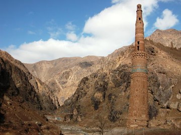
Minaret of Jam
The 65m-tall Minaret of Jam is a graceful, soaring structure, dating back to the 12th century. Covered in elaborate brickwork with a blue tile inscription at the top, it is noteworthy for the quality of its architecture and decoration, which represent the culmination of an architectural and artistic tradition in this region. Its impact is heightened by its dramatic setting, a deep river valley between towering mountains in the heart of the Ghur province.
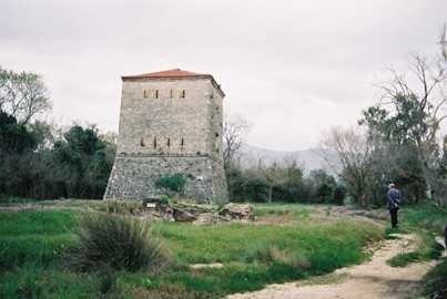
Butrint
Inhabited since prehistoric times, Butrint has been the site of a Greek colony, a Roman city and a bishopric. Following a period of prosperity under Byzantine administration, then a brief occupation by the Venetians, the city was abandoned in the late Middle Ages after marshes formed in the area. The present archaeological site is a repository of ruins representing each period in the city’s development.
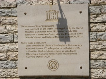
Berat and Gjirokastra
Berat and Gjirokastra are inscribed as rare examples of an architectural character typical of the Ottoman period. Located in central Albania, Berat bears witness to the coexistence of various religious and cultural communities down the centuries. It features a castle, locally known as the Kala, most of which was built in the 13th century, although its origins date back to the 4th century BC. The citadel area numbers many Byzantine churches, mainly from the 13th century, as well as several mosques built unde... Read More
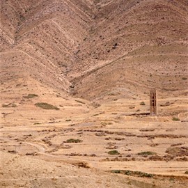
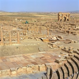
Al Qal'a of Beni Hammad
In a mountainous site of extraordinary beauty, the ruins of the first capital of the Hammadid emirs, founded in 1007 and demolished in 1152, provide an authentic picture of a fortified Muslim city. The mosque, whose prayer room has 13 aisles with eight bays, is one of the largest in Algeria.
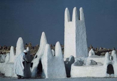
M'Zab Valley
A traditional human habitat, created in the 10th century by the Ibadites around their five ksour (fortified cities), has been preserved intact in the M’Zab valley. Simple, functional and perfectly adapted to the environment, the architecture of M’Zab was designed for community living, while respecting the structure of the family. It is a source of inspiration for today’s urban planners.
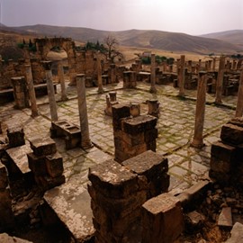
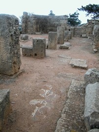
Djémila
Situated 900 m above sea-level, Djémila, or Cuicul, with its forum, temples, basilicas, triumphal arches and houses, is an interesting example of Roman town planning adapted to a mountain location.
Tipasa
On the shores of the Mediterranean, Tipasa was an ancient Punic trading-post conquered by Rome and turned into a strategic base for the conquest of the kingdoms of Mauritania. It comprises a unique group of Phoenician, Roman, palaeochristian and Byzantine ruins alongside indigenous monuments such as the Kbor er Roumia, the great royal mausoleum of Mauretania.
Timgad
Timgad lies on the northern slopes of the Aurès mountains and was created ex nihilo as a military colony by the Emperor Trajan in AD 100. With its square enclosure and orthogonal design based on the cardo and decumanus, the two perpendicular routes running through the city, it is an excellent example of Roman town planning.
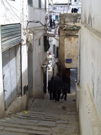
Kasbah of Algiers
The Kasbah is a unique kind of medina, or Islamic city. It stands in one of the finest coastal sites on the Mediterranean, overlooking the islands where a Carthaginian trading-post was established in the 4th century BC. There are the remains of the citadel, old mosques and Ottoman-style palaces as well as the remains of a traditional urban structure associated with a deep-rooted sense of community.
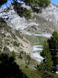
Madriu Perafita Claror Valley
The cultural landscape of Madriu-Perafita-Claror Valley offers a microcosmic perspective of the way people have harvested the resources of the high Pyrenees over millennia. Its dramatic glacial landscapes of craggy cliffs and glaciers, with high open pastures and steep wooded valleys, covers an area of 4,247 ha, 9% of the total area of the principality. It reflects past changes in climate, economic fortune and social systems, as well as the persistence of pastoralism and a strong mountain culture, notably t... Read More
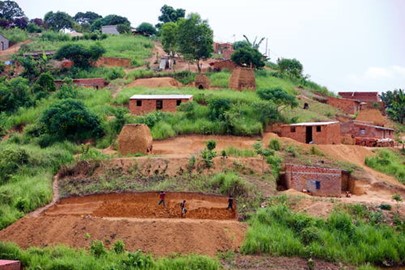
Mbanza Kongo
The town of Mbanza Kongo, located on a plateau at an altitude of 570 m, was the political and spiritual capital of the Kingdom of Kongo, one of the largest constituted states in Southern Africa from the 14th to 19th centuries. The historical area grew around the royal residence, the customary court and the holy tree, as well as the royal funeral places. When the Portuguese arrived in the 15th century they added stone buildings constructed in accordance with European methods to the existing urban conurbation... Read More
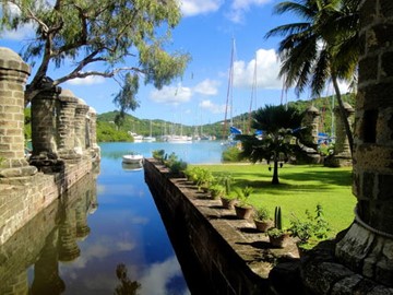
Antigua Naval Dockyard
The site consists of a group of Georgian-style naval buildings and structures, set within a walled enclosure. The natural environment of this side of the island of Antigua, with its deep, narrow bays surrounded by highlands, offered shelter from hurricanes and was ideal for repairing ships. The construction of the Dockyard by the British navy would not have been possible without the labour of generations of enslaved Africans since the end of the 18th century. Its aim was to protect the interests of sugar ca... Read More
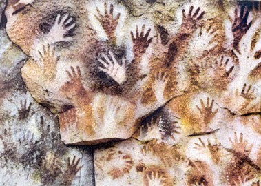
Cueva de las Manos
The Cueva de las Manos, Río Pinturas, contains an exceptional assemblage of cave art, executed between 13,000 and 9,500 years ago. It takes its name (Cave of the Hands) from the stencilled outlines of human hands in the cave, but there are also many depictions of animals, such as guanacos (Lama guanicoe ), still commonly found in the region, as well as hunting scenes. The people responsible for the paintings may have been the ancestors of the historic hunter-gatherer communities of Patagonia found by... Read More
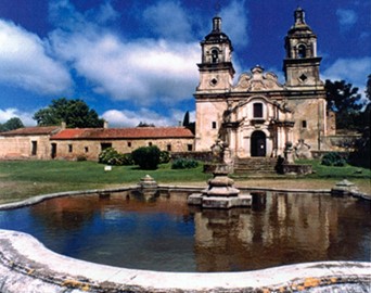
Jesuit Block and Estancias of Córdoba
The Jesuit Block in Córdoba, heart of the former Jesuit Province of Paraguay, contains the core buildings of the Jesuit system: the university, the church and residence of the Society of Jesus, and the college. Along with the five estancias, or farming estates, they contain religious and secular buildings, which illustrate the unique religious, social, and economic experiment carried out in the world for a period of over 150 years in the 17th and 18th centuries.
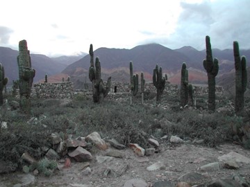
Quebrada de Humahuaca
Quebrada de Humahuaca follows the line of a major cultural route, the Camino Inca, along the spectacular valley of the Rio Grande, from its source in the cold high desert plateau of the High Andean lands to its confluence with the Rio Leone some 150 km to the south. The valley shows substantial evidence of its use as a major trade route over the past 10,000 years. It features visible traces of prehistoric hunter-gatherer communities, of the Inca Empire (15th to 16th centuries) and of the fight for independe... Read More
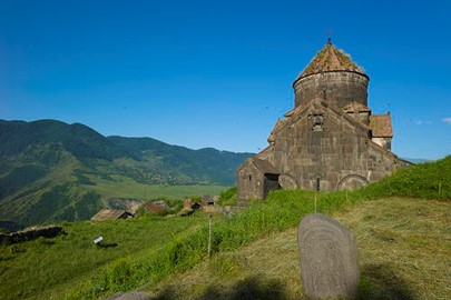
Haghpat and Sanahin Monasteries
These two Byzantine monasteries in the Tumanian region from the period of prosperity during the Kiurikian dynasty (10th to 13th century) were important centres of learning. Sanahin was renown for its school of illuminators and calligraphers. The two monastic complexes represent the highest flowering of Armenian religious architecture, whose unique style developed from a blending of elements of Byzantine ecclesiastical architecture and the traditional vernacular architecture of the Caucasian region.